 The Columbia River Gorge is a great spring destination. It is sunny and warm, and you’ll see hillsides saturated with wildflowers. Spring is also an ideal time to ride the Klickitat Trail, which starts (or ends) in the Gorge community of Lyle.
The Klickitat Trail is 31 miles of gravel rail trail between the Columbia River Gorge and Goldendale Plateau, offering scenic river and canyon views its entire length. The first 13 miles of trail parallel the Klickitat River, most of which is designated a National Wild and Scenic River. A few miles east of Klickitat, the trail turns away from the river and makes its way through remote and lonely Swale Canyon to the ranch lands on the Goldendale Plateau.
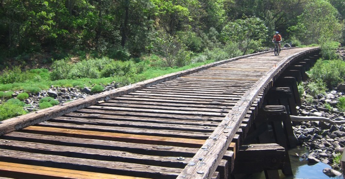
This is not a ride for skinny tires. Most of the trail is unimproved railroad ballast and the ride is often rocky and bumpy. You will cross trestles, some of which are still bone shaking railroad ties. Access points are limited and the area is rural. Carry sufficient water (only the Lyle trailhead has running water and it’s seasonal), food, and flat repair supplies with you. This is also tick and rattlesnake country. We encountered both on our ride.
Lyle to Klickitat (13 miles)
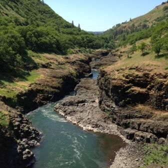
Wild and Scenic Klickitat River
This is the most popular part of the trail, with most trail users concentrated between Lyle and the rebuilt Fisher Hill trestle. You’re almost always within sight and sound of the river, and ponderosa pines offer shady rest stops. Look for members of the Yakama Nation dip netting for fish in the canyon. Most of the trail is adjacent to private property and you will occasionally pass homes and pastures. Please stay on the trail.
This part of the trail can be very flowery, though they were waning when we biked it. We saw and heard lots of birds, including raptors and water fowl. We passed an abandoned homestead where once tended lilacs and cherry trees were now wild.
You must detour to nearby roads at Klickitat due to a missing trestle. The trail corridor resumes several miles away at Wahkiacus.
Swale Canyon (12 miles)
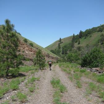
Climbing Swale Canyon
The trail turns up Swale Canyon several miles east of Klickitat. This portion of the trail feels remote and lonely. Conditions dry out quickly in Swale Canyon and the trail is typically closed late June until the middle of October due to high fire danger.
The only other people we met on this portion of the trail was a group of hikers midway in the canyon. We passed a few squatter-like homesteads and found little shade for breaks. The trail climbs gently up to the Harms Road trailhead on the Goldendale Plateau. (The community of Goldendale is still a 20-mile bike ride away.) The trail actually continues another three miles to Warwick, but there is no trailhead there yet.
The Klickitat Trail is jointly managed by Washington State Parks, National Forest Service and Klickitat Trail Conservancy. Visit the Conservancy website for more information on the trail.