Bike Maps in Washington

Washington state bike maps and mapping tools can help you plan your next bike ride or commute route. Below is an alphabetical listing of state and local bike and trails maps for Washington State. Spokane bicyclists launched a crowd-sourced map of bike parking; if your town has one of those let us know and we’ll add that too.
- Bainbridge Island Biking & Walking Guide Page 1 and Page 2
- Bellevue – bike map and bike info
- Bellingham Bike Map (updated 2/5/21)
- Burien Trails and Bicycle Routes (updated 2/5/21)
- Chelan County Apple Capital Loop Trail Map (updated 2/5/21)
- Clark County (updated 2/5/21)
- Coal Mines Trail – map and info about this Cle Elum/Roslyn rail-trail
- Columbia River Gorge Bike Map (updated 11/17/23)
- Columbia Plateau Trail (updated 2/8/21) – map and info
- Cowlitz County Trail Map (updated 7/31/23)
- Ferry County Rail Trail Map (updated 2/19/21)
- Issaquah Bike Map
- Kent Cycling and Walking Guide (updated 11/17/23)
- King County Regional Trails System – maps and info (updated 2/22/21)
- Kirkland Parks and Trails Guide (updated 2/22/21)
- Kitsap County Bicycle Adventure Map (updated 2/22/21)
- Klickitat Trail Map (updated 2/22/21)
- La Conner Bike Maps
- Lewis County Community Trails – info and maps
- Mason County Bicycle Recreation Map (updated 11/17/23)
- Moses Lake Activity Trails Map
- North Kitsap Trails Maps (updated 4/21/21)
- Olympic Discovery Trail
- Olympic Peninsula / Port Angeles Bicycling (updated 11/17/23)
- Palouse to Cascades Trail Maps (updated 2/19/21)
- Pierce County Bike Map
- Port Townsend Bike routes (updated 4/28/21)
- Pullman Trails & Pathways (updated 4/28/21)
- Redmond Bicycling Maps (updated 4/28/21)
- Renton Trails and Bicycle Guide Map (updated 4/28/21)
- San Juan Island Trails – info and maps
- Seattle Bike Map
- Seattle Burke Gilman Trail Map (updated 4/28/21)
- Skagit County Bike Maps (updated 4/28/21)
- Snohomish County Bike Map (updated 4/28/21)
- Snohomish County Centennial Trail Map (updated 4/17/24)
- Snohomish County Interurban Trail Map (updated 4/28/21)
- Spokane River Centennial Trail
- Spokane Regional Interactive Bike Map (updated 4/28/21)
- Spokane Region Maps – bike maps and recreation rides for areas around Spokane
- Spokane Valley Bike Map (updated 4/28/21)
- Spokane area bike parking map (crowdsourced–add Spokane bike racks and indoor bike storage facilities)
- Tacoma
- Thurston County Bike Map
- Tri-Cities Bike Map (updated 4/28/21)
- Vancouver/Portland Area Bike Maps (updated 4/28/21)
- Vashon Island Bike Maps – bike routes and mountain bike trails (updated 4/28/21)
- Walla Walla Bike Maps (updated 6/1/23)
- Washington Rail-Trails (updated 4/28/21)
- Washington State Ferries info
- Wenatchee Bike Map (updated 4/28/21)
- Willapa Hills Trail – information and map – this trail between Chehalis and South Bend is partially developed
- Yakima Bike Map (updated 4/28/21)
- Yakima Greenway Map (updated 4/28/21)
Where Can’t I Ride My Bike in Washington?
Please visit WSDOT’s map of Permanent Bike Restrictions along highways and state routes. Note, some of these routes do not allow bikes on the roadway, but may have dedicated bike and pedestrian access directly adjacent to those routes (such as the I-90 and SR 520 bridges across Lake Washington). Interact with the map by clicking on the desired route to see these details.
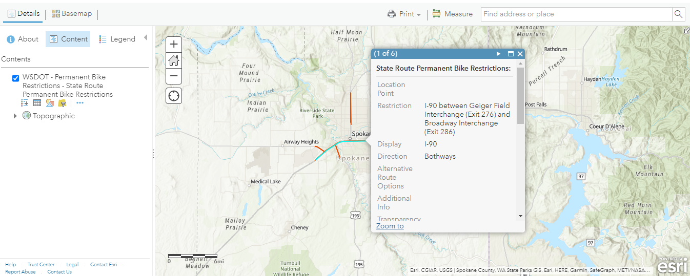
The WSDOT map allows you to view specific segments of highways and routes that are permanently closed to bicycle traffic.
Other Maps and Mapping Tools